


- Home
- Scarrows
- Mariners
- Cumberland
- Miscellaneous
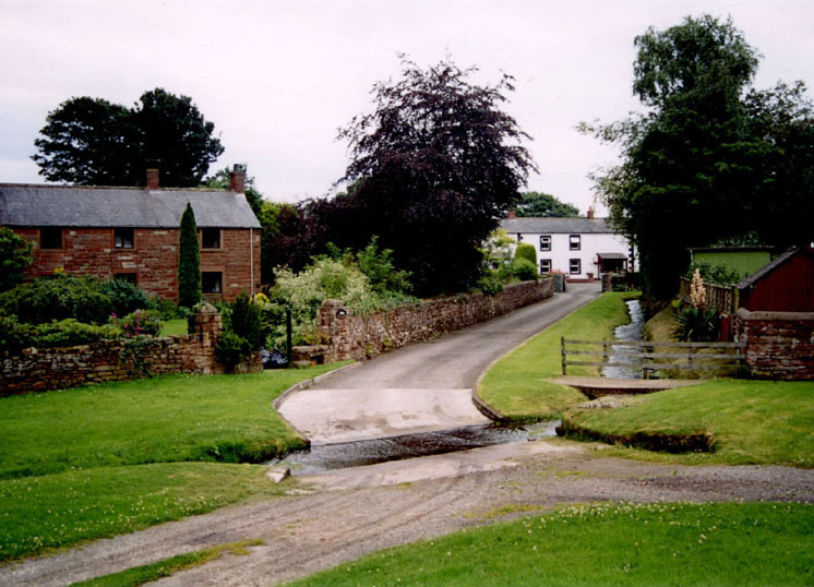
Cumwhitton
Cumwhitton is priniciply are farming village, and is the place where the earliest of the Scarrows resided, or at least as far back as the records go which is around 1600. The most comprehensive information from this time comes from the Gilsland Survey map from 1603, which shows all the farms, dwellings and their occupiers. It was accompanied by a field study, and was also the subject of a thesis in 1973 by H.J. Charnley. These documents relate to the Barony of Gilsland, and are part of the Haworth Collection held at Cumbria Archives.
At this period in time, six Scarrow families were living in the Manor of Cumwhitton - Anthonie Scarrow, James Scarrow, John Scarrow, Robert Scarrow (two households) and Rowland Scarrow.
The village is about seven miles S. by W. of Brampton. There were formerly on the village green two artificial mounds, which had been used as butts in the good old days, when the stout yeomen of Cumberland prided themselves upon their skill in archery. These mounds were known as High and Low Willy Wastel, "probably from the great archer recorded in song."
Village Description 1884 T. Bulmer
Cumwhitton lies on the east side of the river Eden, and is bounded on the north by Great Corby, on the south by Leath Ward, on the east by Cumwhitton and Carlatton, and on the west by the above-named river. In 1847, and for some years subsequently, there were 5,670 acres in the parish subject to assessment; at present the rateable acreage is only 5,170, of which the gross estimated rental is £4,875 15s. 6d., and assessment value £4,388. This, like many other purely agricultural parishes, has witnessed a decrease in its population during recent years; in 1841 there were 533 inhabitants, and in 1881, 497.
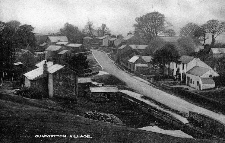
The soil is light and stony, producing barley, oats, a little wheat, and excellent potatoes. The climate is cold but invigorating and healthy. In the southern part of the parish is a tract of dreary treeless waste, commonly called King Harry, where, according to tradition, one of the kings of England who bore that name encamped with his army. Tradition has not preserved any distinguishing feature to enable us to indicate the king alluded to, but we know that the unfortunate Henry VI., after the battle of Hexham, fled into Cumberland, and may probably have had with him a remnant of his army, and encamped here. A stone is pointed out from which, it is said, King Harry mounted his charger. A portion of this moor has, during recent years, been brought into cultivation, but still there remains a large extent of unattractive and uninviting waste, from which the traveller recoils.
Upon an eminence near the centre of this moor are the remains of a Druidical circle, which formerly consisted of eighty-eight stones, and was fifty-two yards in diameter. It is designated in the locality Grey Yauds, from the colour of the stones, of which there now remains only one, and yaud, a north country name for a horse. At Cairn Head, on the eastern side of King Harry, and within a space of twelve yards, are three springs, from which issue volumes of water sufficiently large to form, when united, a brook of considerable mag- nitude. These springs are not only the most copious, but also the purest in the county. The parish is divided into two townships, viz., Cumwhitton and Northsceugh-with-Moorthwaite.
Cumwhitton township comprises 2,634 acres, of which the rateable value is £2,340, and the gross estimated rental, £2,607.
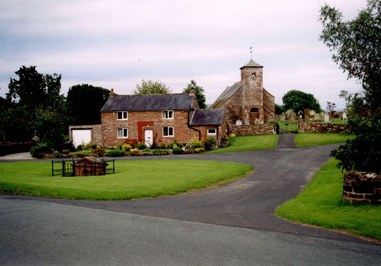
Church History
The church, dedicated to St. Mary, is an ancient structure, consisting of nave, chancel, and tower. The period of its first erection is not known, but a church occupied the spot when the Valor of Pope Nicholas was taken, in 1291, at which time it was returned as a rectory, valued at £8 14s. 6d. A few years later, when Edward II., in order to raise money laid a tax on church livings, Cumwhitton, or as it was then called Cumquintington, escaped on account of its poverty. This church was possessed of rectorial privileges until appropriated to the priory of Carlisle by one of the early lords. After the suppression of monastic establishments, all the church patronage, held by the prior of Carlisle, was transferred to the Dean and Chapter, who have since continued to exercise that privilege. The tithes were commuted in 1840 for a yearly rent-charge of £175, viz., great tithes for £105, and meal tithes £70. Hutchinson tells us that "the Dean and Chapter demise all the rectory of Cumwhitton, except the curate's house and garden, viz., all the glebe lands and meadows called Kirkcroft, tithes, oblations, &c., under the yearly rent of fifteen eskeps of haver meal, and 10s. in money, besides the curate's stipend of £10." The living is now worth £295, and is held by the Rev. William Maudsley. There is very little in the church requiring special mention. A small circular window of stained glass has been inserted in the south side to the memory of the Rev. John Leach, incumbent of Berwick-upon-Tweed, and member of a family resident in this parish for many generations ; and a new bell, raised by subscription, has been recently placed in the tower. The vicarage, erected about 50 years ago, is a very plain building, situated at the south end of the village.
Cumwhitton Inhabitants 1603
The map below shows the dwellings of the centre Cumwhitton in 1603. There are similar maps produced for Scarrowhill, Moorfoote and Norskue (see Scarrowhill section).
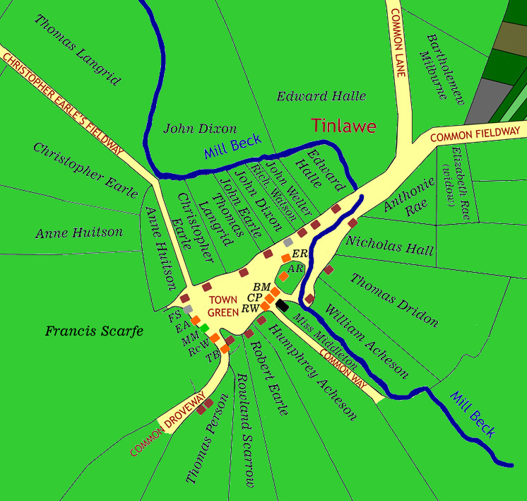
Just one of the Scarrows, Rowland, resided in the village itself, with the others clustered around Scarrowhill. The table below is a key to the name abbreviations:
| AR | Anthonie Rae |
| BM | Bartholemew Milburne |
| CP | Christopher Person |
| EA | Elizabeth Atkinson |
| ER | Elizabeth Rae |
| FS | Francis Scarfe |
| MM | Miss Middleton |
| RcW | Richard Watson |
| RW | Roland Wilson |
| TB | Thomas Burthom |
For the complete picture of Cumwhitton, click here, which will open the picture in a new window.
Cumwhitton Viking Burial Site
A number of exceptionally rare Viking burials, probably dating from the early 10th century, have recently been discovered on farmland at Cumwhitton, Cumbria. Excavations carried out by Oxford Archaeology North found six richly furnished graves, containing swords, spears, jewellery and the remains of spurs and a possible horse harness. Other than a small fragment of skull no human bone had survived in the acid soil conditions, but the objects found in the graves suggest that four men and two women had been buried here.
To date, all the Viking burials that have been identified in the North West are high status individuals who probably represent the first generation of settlers who died as pagans but whose heirs rapidly converted to Christianity. The fact that the Cumwhitton burials were all aligned roughly east/west could be indicative of individuals with leanings towards Christianity who were buried in a richly-furnished pagan-style, perhaps as an example of 'cultural conservatism' designed to establish the presence in the landscape of recently established Norse-dominated territories.
This discovery is of immense significance for our understanding of the early medieval period in the North West. It has been noted that 'extraordinarily few' Viking graves have been discovered in Western Europe, despite the extensive period of Norse influence, and certainly only very limited numbers of apparently Viking Age burials have been found in the North West, the majority in Cumbria. Without exception, these have been recorded in an antiquarian context, no new sites having been recorded for more than an hundred years. In all, only 12 possible or certain Viking Age burials have been identified in Cumbria and Lancashire and the majority of the recorded burials were found as single graves, some apparently in purpose-built mounds, or re-using prehistoric monuments.